Sim-Wings Wasserkuppe Airfield Benutzerhandbuch
- Typ
- Benutzerhandbuch

Manual
DLC
ASSERKUPPE
AEROSOFT AIRFIELD
W

AEROSOFT AIRFIELD WASSERKUPPE
Aerosoft GmbH 2021
2 3
Developed by: Stairport Sceneries
Manual: Stairport Sceneries , Aerosoft GmbH
Datengrundlage / Hessische Verwaltung für Bodenma-
Aerial Image Provider: nagement und Geoinformation
Handbuch
Manual
AEROSOFT AIRFIELD
Wasserkuppe
Copyright: © 2021 / Aerosoft GmbH
Airport Paderborn/Lippstadt
D-33142 Büren, Germany
Tel: +49 (0) 29 55 7603-10
Fax: +49 (0) 29 55 7603-33
Internet: www.aerosoft.com
All trademarks and brand names are trademarks or registered
trademarks of their respective owners. All rights reserved. /
Alle
Warenzeichen und Markennamen sind Warenzeichen oder eingetragene
Warenzeichen ihrer jeweiligen Eigentümer.
Alle Urheber- und Leistungs-
schutzrechte vorbehalten
.
Erweiterung für
Add-on for
Microsoft Flight Simulator

AEROSOFT AIRFIELD WASSERKUPPE
Aerosoft GmbH 2021
4 5
Inhalt
Zu Beginn ...................................................................6
Systemanforderungen ........................................................... 6
Support ................................................................................. 7
Urheberrechte ....................................................................... 7
Der Flugplatz .............................................................8
Geografie ............................................................................. 8
Geschichte ........................................................................... 8
Technische Angaben .............................................................. 9
Runways ................................................................................ 9
Radiofrequenzen ................................................................... 9
Szenerie-Features ................................................... 10
Contents
Starting Off .............................................................11
System Requirements........................................................... 11
Support ............................................................................... 12
Copyrights ........................................................................... 12
The Airfield ..............................................................13
Geography ......................................................................... 13
History ................................................................................ 13
Technical Information .......................................................... 14
Runways .............................................................................. 14
Radio Frequencies ............................................................... 14
Scenery Features ....................................................15

AEROSOFT AIRFIELD WASSERKUPPE
Aerosoft GmbH 2021
6 7
Deutsch
Support
Support für dieses Produkt wird von Aerosoft bereitgestellt. Wir
bevorzugen ein Supportforum, da es schnell und effizient ist, weil
Kunden sich gegenseitig helfen können, wenn wir nicht im Büro sind:
Support-Forum:
http://forum.aerosoft.com/
Wenn Sie E-Mail-Support bevorzugen:
https://helpdesk.aerosoft.com/portal/newticket
Bitte beachten Sie, dass E-Mail-Support langsam sein kann, wenn wir
stark beschäftigt sind (zum Beispiel kurz nach einem Release). Wie
versuchen, binnen 24 Stunden auf Sie zurückzukommen, aber wenn
Sie eine schnelle Antwort möchten, empfehlen wir das Forum.
Support ist uns sehr wichtig. Der Kauf eines unserer Produkte gibt
Ihnen das Recht, uns mit Fragen zu löchern, die Sie vielleicht dumm
finden. Sie sind es nicht. Wir bieten Support auf Deutsch, Englisch,
Niederländisch, Französisch, Spanisch und Portugiesisch.
Urheberrechte
Die Software, das Handbuch und sonstiges zugehöriges Material sind
durch Urheberrechtsgesetze geschützt. Die Software wird lizenziert,
nicht verkauft. Sie dürfen eine Kopie der Software auf einem Compu-
ter für Ihre persönliche, nichtkommerzielle Nutzung installieren und
ausführen. Die Software, das Handbuch und alle anderen zugehö-
rigen Materialien dürfen ohne vorherige schriftliche Erlaubnis der
Entwickler der Software und der Aerosoft GmbH weder kopiert,
fotokopiert, übersetzt, zurückentwickelt, dekompiliert, disassembliert
oder in anderer Form für elektronische Maschinen lesbar gemacht
werden.
Zu Beginn
Systemanforderungen
Um die Szenerie „Aerosoft Airfield Wasserkuppe“ möglichst störungs-
frei anfliegen zu können, benötigen Sie:
• Microsoft Flight Simulator
• Betriebssystem: Windows 10 (Nov 2019 Update - 1909)
• DirectX: DirectX 11
• Prozessor: Intel i5-4460 -oder- Ryzen 3 1200 oder besser
• Grafik: NVIDIA GTX 770 -oder- Radeon RX 570 oder besser
• Videospeicher: 2 GB
• Arbeitsspeicher: 8 GB
• Festplattenspeicher: 5 GB
• Bandbreite: 5 Mbp

AEROSOFT AIRFIELD WASSERKUPPE
Aerosoft GmbH 2021
8 9
Deutsch
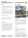
Der Flugplatz
Geografie
Der Flugplatz Wasserkuppe liegt am Nordhang der hessischen Rhön
im Landkreis Fulda. Er ist als Sonderlandeplatz klassifiziert und liegt
902m (2959ft) über Normalnull. Damit ist er der höchstgelegene
Flugplatz Deutschlands.
Die eigentliche Wasserkuppe liegt nochmal etwas höher, auf 950,2
Meter über Normalnull. Die nächsten Dörfer/Gemeinden in der
Umgebung sind Gersfeld (5km nördlich), Poppenhausen (5km
west-südwestlich) und Wüstensachsen (a. 5km östlich).
Geschichte
Die Wasserkuppe wird bereits seit 1911 als Fluggelände benutzt. Zu
dieser Zeit nutzten Schüler aus Darmstadt das Gelände um Versuche
mit selbst gebauten Gleitern durchzuführen.
Die erste Flugschule wurde dann 1922 durch Arthur Martens gegründet.
Über die Jahre hinweg veränderte sich das Aussehen des Fluglatzes
sehr, so wurde zum Beispiel die Schneise für die Start- und Landebahn
im Winter 1958/59 in den Wald geschlagen. 1981 wurde die Bahn
auf einer Länge von 400 Meter asphaltiert und 1997 saniert und auf
die aktuelle Länge erweitert.
Im Jahr 2012 wurde das neue Flugplatzgebäude mit Schulungsräumen,
Büros, Hangars für Motorflugzeuge und einem neuen Turm errichtet.
Weitere interessante Infos zur Wasserkuppe und Gebäude /Orte wie
das Fliegerdenkmal oder zum Beispiel das Radom Wasserkuppe finden
Sie unter folgenden Links.
Wasserkuppe
https://de.wikipedia.org/wiki/Wasserkuppe
Flugplatz Wasserkuppe
https://de.wikipedia.org/wiki/Flugplatz_Wasserkuppe
Technische Angaben
Name: Flugplatz Wasserkuppe
ICAO: EDER
IATA: -
Koordinaten: 50° 29‘ 58‘‘ N
9° 56‘ 58‘‘ O
Höhe über MSL: 2959ft (902 m)
Runways
06/24 2103ft (641 m) Asphalt/Gras
Radiofrequenzen
INF 120.130 MHz

AEROSOFT AIRFIELD WASSERKUPPE
Aerosoft GmbH 2021
10 11
English
Szenerie-Features
• Eigens erstellte Gebäude für den Flugplatz und die Umgebung
• Angepasstes Orthofoto für den Flugplatz und die Umgebung
• Saisonale Animationen für verschiedene Objekte
• Radom und Fliegerdenkmal POI enthalten
• Realistisches Pistenneigungsprofil
• Eigene statische Flugzeuge je nach Wetter und Jahreszeit
• Segelflugzeuge fliegen in der Umgebung (sofern es das Wetter
zulässt)
Starting Off
System Requirements
In order for the scenery “Aerosoft Airfield Wasserkuppe” to run as
smoothly as possible, you need the following:
• Microsoft Flight Simulator
• OS: Windows 10 (Nov 2019 Update - 1909)
• DirectX: DirectX 11
• CPU: Intel i5-4460 -or- Ryzen 3 1200 or better
• GPU: NVIDIA GTX 770 -or- Radeon RX 570 or better
• VRAM: 2 GB
• RAM: 8 GB
• HDD: 5 GB

AEROSOFT AIRFIELD WASSERKUPPE
Aerosoft GmbH 2021
12 13
English
Support
Support for this product is offered by Aerosoft. We prefer to have a
support forum for the simple reason that it is fast and efficient
because customers help customers when we are not in the office:
http://forum.aerosoft.com/
And we advise the Scenery section in the Microsoft Flight Simulator
subforum for any questions on this product. This should be your first
stop for any support. If you prefer support by email please do accept
that this could take a bit longer as it might be sent from person to
person if necessary, and that email support during the weekends is
always slow:
https://helpdesk.aerosoft.com/portal/home
We feel strongly about support. Buying one of our products gives you
the right to waste our time with questions you feel might be silly.
They are not.
Copyrights
This software, the manual, documentation, video images, and all the
related materials are protected by copyright laws. The software is
licensed, not sold. You may install and run one copy of the software
on one computer for your personal, non-commercial use. The
software, the manual and all related materials must not be copied,
photocopied, translated, reverse engineered, decompiled or reduced
to any electronic medium or machine legible form, neither complete-
ly nor in part, without the previous written permission of the
developers of this software and Aerosoft GmbH.
The Airfield
Geography
Wasserkuppe airfield is located on the northern hillside of the Hessian
Rhön in the district of Fulda. It is classified as a special airfield and lies
902m (2959ft) above sea level. This is the highest airfield in Germany.
The real Wasserkuppe is a little higher up, at 950.2 metres above sea
level. The nearest villages/towns in the surrounding area are Gersfeld
(5km north), Poppenhausen (5km west-southwest) and Wüstensach-
sen (5km east).
History
The Wasserkuppe has been used as a flying field since 1911. At that
time, students from Darmstadt used the area to conduct experiments
with self-built gliders.
The first flying school was then founded in 1922 by Arthur Martens.
Over the years, the airfield’s appearance changed a lot, for example,
the forest was cut for the runway in the winter of 1958/59. In 1981,
the runway was asphalted over a length of 400 metres, and in 1997 it

AEROSOFT AIRFIELD WASSERKUPPE
Aerosoft GmbH 2021
14 15
English
was modernised and extended to its current length.
In 2012, the new airfield building was constructed with training
rooms, offices, hangars for motorised aircraft and a new tower.
You can find more interesting information about the Wasserkuppe
and buildings/locations such as the Aviation Memorial or, for example,
the Wasserkuppe Radome under the following links.
Wasserkuppe
https://en.wikipedia.org/wiki/Wasserkuppe
Technical Information
Name: Airfield Wasserkuppe
ICAO: EDER
IATA: -
Coordinates: 50° 29’ 58’’ N
9° 58’ 58’’ O
Elevation AMSL: 2959ft (902 m)
Runways
06/24 2103ft (641 m) Asphalt/Grass
Radio Frequencies
INF 120.130 MHz
Scenery Features
• Custom buildings covering the airfield and the surrounding
area
• Custom orthophoto covering the airport and surrounding
• Seasonal animations for various objects
• Radome and Fliegerdenkmal POI included
• Realistic runway slope profile
• Custom static aircrafts depending on weather and season
• Gliders flying in the vicinity (if weather permits)

MF 16
English
FLIGHT SIMULATOR
A GUIDE TO
-
 1
1
-
 2
2
-
 3
3
-
 4
4
-
 5
5
-
 6
6
-
 7
7
-
 8
8
-
 9
9


Sim-Wings Wasserkuppe Airfield Benutzerhandbuch
- Typ
- Benutzerhandbuch
in anderen Sprachen
Verwandte Papiere
-
 Sim-Wings Perranporth Airfield Benutzerhandbuch
-
 Sim-Wings Lido di Venezia Benutzerhandbuch
-
 Sim-Wings East Frisian Islands Airfield Benutzerhandbuch
-
 Sim-Wings Trondheim Airport Benutzerhandbuch
-
 Sim-Wings Trondheim-Vaernes X v2.0 Benutzerhandbuch
-
 Sim-Wings Approaching Dortmund Benutzerhandbuch
-
 Sim-Wings Vitoria-Foronda Airport Instructions Manual
-
 Sim-Wings Napoli X Benutzerhandbuch
-
 Sim-Wings German Airports 1 Friedrichshafen X Benutzerhandbuch
-
 Sim-Wings Mallorca X Evolution Benutzerhandbuch


