Sim-Wings Mega Airport Brussels Benutzerhandbuch
- Typ
- Benutzerhandbuch

RUSSELS
AEROSOFT MEGA AIRPORT
B
Manual

Aerosoft Mega Airport Brussels
Aerosoft GmbH 2022
2 3
Developed by: Jo Erlend Sund
Manual: Jo Erlend Sund, Aerosoft GmbH
Handbuch
Manual
Brussels
Copyright: © 2022 / Aerosoft GmbH
Airport Paderborn/Lippstadt
D-33142 Büren, Germany
Tel: +49 (0) 29 55 7603-10
Fax: +49 (0) 29 55 7603-33
Internet: www.aerosoft.com
All trademarks and brand names are trademarks or registered
trademarks of their respective owners. All rights reserved. /
Alle
Warenzeichen und Markennamen sind Warenzeichen oder eingetragene
Warenzeichen ihrer jeweiligen Eigentümer.
Alle Urheber- und Leistungs-
schutzrechte vorbehalten
.
Erweiterung für
Add-on for
Microsoft Flight Simulator
Aerosoft Mega Airport

Aerosoft Mega Airport Brussels
Aerosoft GmbH 2022
4 5
Inhalt
Zu Beginn ...................................................................6
Systemanforderungen ........................................................... 6
Installation und Aktivierung ................................................... 6
WIE FINDE ICH DEN FLUGHAFEN IM MICROSOFT
FLIGHT SIMULATOR? .................................................. 6
Support ................................................................................. 7
Urheberrechte ....................................................................... 7
Der Flughafen ...........................................................8
Geschichte ................................................................. 8
Ein dynamischer Flughafen ....................................... 10
Warnsystem auf dem Vorfeld ................................... 10
Dynamische Hangartore ........................................... 11
KI-Verkehr ................................................................ 11
Visual Guidance Docking System (VDGS) .................. 11
Flughafen Daten .................................................................. 15
Start- und Landebahnabstände................................. 15
Intersection Take-off Distances ................................. 15
Empfohlene Einstellungen ........................................ 16
ATC Facilities ............................................................ 17
Navigational Aids ..................................................... 17
Szenerie-Features ................................................... 18
Orthographische Bilder .......................................... 19
Contents
Starting Off .............................................................20
System Requirements........................................................... 20
Installing and Activation ...................................................... 20
FINDING THE AIRPORT IN MICROSOFT FLIGHT SIMULA-
TOR ......................................................................... 20
Support ............................................................................... 21
Copyrights ........................................................................... 21
The Airport .............................................................22
History ................................................................................. 22
A Dynamic Airport ............................................................... 24
Apron Warning System ........................................................ 24
Dynamic Hangar Doors ........................................................ 24
AI Traffic .............................................................................. 25
Visual Guidance Docking System (VDGS) ............................. 25
Airport Data ........................................................................ 28
Declared Runway Distances ...................................... 28
Intersection Take-off Distances ................................. 28
Recommended Settings ............................................ 29
ATC Facilities ............................................................ 30
Navigational Aids ..................................................... 30
Scenery Features ....................................................31
Orthographic Images .............................................32

Aerosoft Mega Airport Brussels
Aerosoft GmbH 2022
6 7
Deutsch
Support
Support für dieses Produkt wird von Aerosoft bereitgestellt. Wir
bevorzugen ein Supportforum, da es schnell und effizient ist, weil
Kunden sich gegenseitig helfen können, wenn wir nicht im Büro sind:
Support-Forum: http://forum.aerosoft.com/
Wenn Sie E-Mail-Support bevorzugen: https://helpdesk.aerosoft.com/
portal/newticket
Bitte beachten Sie, dass E-Mail-Support langsam sein kann, wenn wir
stark beschäftigt sind (zum Beispiel kurz nach einem Release). Wie
versuchen, binnen 24 Stunden auf Sie zurückzukommen, aber wenn
Sie eine schnelle Antwort möchten, empfehlen wir das Forum.
Support ist uns sehr wichtig. Der Kauf eines unserer Produkte gibt
Ihnen das Recht, uns mit Fragen zu löchern, die Sie vielleicht dumm
finden. Sie sind es nicht. Wir bieten Support auf Deutsch, Englisch,
Niederländisch, Französisch, Spanisch und Portugiesisch.
Urheberrechte
Die Software, das Handbuch und sonstiges zugehöriges Material sind
durch Urheberrechtsgesetze geschützt. Die Software wird lizenziert,
nicht verkauft. Sie dürfen eine Kopie der Software auf einem Compu-
ter für Ihre persönliche, nichtkommerzielle Nutzung installieren und
ausführen. Die Software, das Handbuch und alle anderen zugehö-
rigen Materialien dürfen ohne vorherige schriftliche Erlaubnis der
Entwickler der Software und der Aerosoft GmbH weder kopiert,
fotokopiert, übersetzt, zurückentwickelt, dekompiliert, disassembliert
oder in anderer Form für elektronische Maschinen lesbar gemacht
werden.
Zu Beginn
Systemanforderungen
Um die Szenerie „Aerosoft ;Mega Airport Brussels“ möglichst
störungsfrei anfliegen zu können, benötigen Sie:
• Microsoft Flight Simulator
• Betriebssystem: Windows 10 (Nov 2019 Update - 1909)
• DirectX: DirectX 11
• Prozessor: Intel® Core™ i7-4790 oder besser
• Grafik: NVIDIA GeForce GTX 970, GDDR5 oder besser
• Videospeicher: 2 GB
• Arbeitsspeicher: 16 GB
• Festplattenspeicher: 3,5 GB
Installation und Aktivierung
Die Installation des DLCs Aerosoft ;Mega Airport Brussels ist ganz
einfach. Führen Sie einfach das Installationsprogramm aus und es
wird automatisch Ihren MSFS-Speicherort finden. Nun müssen Sie nur
noch den Registrationscode eingeben und das Produkt ist aktiviert.
Nach Abschluss des Installationsvorgangs sollte das Produkt innerhalb
Ihrer MSFS-Sim-Plattform voll funktionsfähig sein. Eine manuelle
Aktivierung des Produkts im Simulator ist nicht erforderlich.
WIE FINDE ICH DEN FLUGHAFEN IM MICROSOFT
FLIGHT SIMULATOR?
Sie finden den Flughafen, indem Sie “Brussels” auf der Weltkarte
auswählen. Alternativ können Sie auch “EBBR” in das Feld für den
Abflughafen eintragen.

Aerosoft Mega Airport Brussels
Aerosoft GmbH 2022
8 9
Deutsch
Der Flughafen
Fliegen Sie nach Brüssel, dem Herzen Europas! Brüssel ist nicht nur die
Hauptstadt Belgiens, sondern wird von vielen auch als die tatsächliche
Hauptstadt Europas angesehen. Nach dem Zweiten Weltkrieg war
Brüssel das Zentrum der europäischen und globalen Politik. Die Stadt
beherbergt zudem zahlreiche Unternehmen und Nichtregierungsorga-
nisationen.
Eine geschäftige Stadt braucht natürlich auch einen Flughafen, der in
der Lage ist, alles vom durchschnittlichen Touristen über den koffer-
tragenden CEO bis hin zum überlasteten Diplomaten oder sogar den
einen oder anderen Staatsoberhaupt abzufertigen.
Der Flughafen Brüssel oder Brussels-National, wie er auch genannt
wird, liegt 12 km nordöstlich von Brüssel in der Gemeinde Zaventem.
Mit fast 25 Millionen Passagieren im Jahr 2019 war er der 24.
verkehrsreichste Flughafen Europas.
Er verfügt über drei Start- und Landebahnen, von denen die längste knapp
über 3.600 m lang ist und sich auf zwei parallele Start- und Landebahnen
(07L/25R & 07R/25L) und eine Querwindbahn (01/19) verteilt.
Nördlich vom Flughafen Brüssel befindet sich der Luftwaffenstütz-
punkt Melsbroek, der Sitz der Transportstaffel der belgischen Luft-
streitkräfte. Obwohl er ein eigener Flugplatz ist, teilt er sich die
gleichen Start- und Landebahnen wie der Flughafen Brüssel.
Geschichte
Die Geschichte der Luftfahrt in dem Gebiet um Brüssel begann
während des Ersten Weltkriegs mit dem Bau eines Hangars, der zur
Unterbringung deutscher Luftschiffe diente. Nach dem Krieg befan-
den sich der Hangar und andere Einrichtungen in den damaligen
Gemeinden Haren und Evere im nordöstlichen Teil von Brüssel,
westlich des heutigen Flughafens.
Durch die großen Fortschritte in der Luftfahrt in der Zwischenkriegs-
zeit nahm der zivile Luftverkehr ständig zu. In den 1920er Jahren
wurde der Bau eines neuen Terminals genehmigt, welches 1929
zusammen mit einem Betonvorfeld für den Komfort der Passagiere
eröffnet wurde.
Der Flughafen war damals nicht viel mehr als eine große Grasfläche,
auf der die Flugzeuge einfach in die Richtung starteten, in der der
Wind am günstigsten war.
Zunächst wurde der Flughafen hauptsächlich von der Sabena (der
damaligen nationalen belgischen Fluggesellschaft) angeflogen, in den
1930er Jahren dann von mehreren internationalen Fluggesellschaften
wie Lufthansa, KLM und Air France.
Durch den starken Anstieg des Luftverkehrs und des nicht absehbaren
Endes der Entwicklung forderten viele einen weiteren Ausbau und
eine Modernisierung des Flugplatzes, um den Anforderungen der
Zukunft besser gerecht zu werden.
Dazu kam es jedoch nicht, da der zerbrechliche Frieden in Europa mit
dem Ausbruch des Zweiten Weltkriegs im Jahr 1939 zerrüttet wurde.
Der Flughafen an seinem heutigen Standort entstand 1940 nach der
deutschen Besetzung Belgiens, als mit dem Bau von drei Start- und
Landebahnen in Dreiecksform begonnen wurde, die als Reserveflug-
platz für die Luftwaffe dienen sollten. Das damals als „Fliegerhorst
Melsbroek“ bezeichnete Flugfeld legte den Grundstein für den
heutigen Flughafen.
Als die deutschen Besatzer die Einheimischen fragten, welches Gebiet
sich für einen Flugplatz eignen würde, wiesen sie gerne auf dieses
Grundstück hin, wohl wissend, dass diese Gegend für ihre Nebel-
schwaden berüchtigt war.
Nach dem Ende des Zweiten Weltkriegs verlagerte sich der zivile
Flugverkehr allmählich von Haren nach Melsbroek. 1948 wurde der
zivile Flugplatz in Melsbroek eröffnet.
Mit der raschen Ausweitung des zivilen Flugverkehrs im Jet-Zeitalter
wurden die Flughafeneinrichtungen und die Start- und Landebahnen
ständig an die sich ändernden Anforderungen angepasst.
Im Jahr 1973 wurde der sogenannte „Satellit“ fertiggestellt und in
Betrieb genommen. Dieses Gebäude steht noch heute, obwohl es
inzwischen zu Büroflächen umgebaut wurde.

Aerosoft Mega Airport Brussels
Aerosoft GmbH 2022
10 11
Deutsch
Das moderne Terminallayout von Brüssel besteht heutzutage aus zwei
Flugsteigen: A und B. Diese sind durch ein Gebäude („Connector“
genannt) verbunden, das einen unterirdischen Tunnel ersetzt, der
früher für den Transit zwischen den beiden Flugsteigen genutzt
wurde. Flugsteig A dient für Inlands- und EU/Schengen-Flüge,
während Flugsteig B für internationale Flüge genutzt wird.
Ein dynamischer Flughafen
Die Szenerie verwendet eine große Anzahl von Skript, um den
Flughafen zum Leben zu erwecken. Diese Skripte reichen von
einfachen „Go here then go here“-Befehlen für Passagiere, die sich
im Terminal bewegen, oder für Fahrzeuge, die auf den Vorfeldstraßen
fahren, bis hin zu komplexeren Skripten.
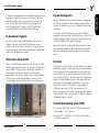
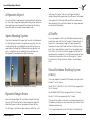
Warnsystem auf dem Vorfeld
Wenn Sie sich den Flughafen genauer ansehen, stellen Sie fest, dass
überall ein System mit drei Leuchten, das so genannte Vorfeldwarnsy-
stem, installiert ist. Diese Leuchten sind in der Regel hoch oben an
Flutlichtanlagen oder Wänden angebracht, damit sie von den
Vorfeldarbeitern leicht gesehen werden können. Ein orangefarbenes
Licht leuchtet bei starkem Wind und Böen, ein rotes Licht, wenn
Gewitter drohen, und ein blaues Licht bei Schnee und Vereisung.
Das Bild zeigt das Vorfeldwarnsystem unter verschiedenen Bedingungen.
Dynamische Hangartore
Einige der Hangartore (TUI und Lufthansa Hangar) und Rampentore
(auf TWY N4 und neben dem Sabena Aerospace Hangar) öffnen und
schließen sich automatisch, wenn Sie sich dem Bereich nähern oder
ihn verlassen.
Die Skripte für den TUI-Hangar haben eine gewisse Zufälligkeit
eingebaut, so dass der Hangar zu bestimmten Zeiten „aufwacht“ und
zufällige Animationen auslöst, was dazu beiträgt, etwas mehr Leben
und Geschäftigkeit auf den Flughafen zu bringen.
Wenn Sie sich dem TUI-Hangar nähern, während eine dieser zufäl-
ligen Animationen abgespielt wird, müssen diese beendet werden,
bevor sich die Hangartore aufgrund der Nähe zu Ihrem Flugzeug
öffnen.
KI-Verkehr
Die Szenerie unterstützt KI-Verkehr mit ICAO definierten Parkcodes.
Grundsätzlich sagen diese Codes dem KI-Verkehr, wo dieser parken
darf. Im Allgemeinen wird dies verwendet, um zu verhindern, dass
der Frachtverkehr um die Terminals herum parkt und um ein realisti-
scheres Layout zu erhalten, in dem die verschiedenen Fluggesellschaf-
ten parken. Es gibt allerdings einige Einschränkungen, sodass der
KI-Verkehr an einem zufälligen Standplatz parkt, wenn es einen
Überlauf gibt und er keinen Standplatz mit einem geeigneten
ICAO-Code finden kann. Die ICAO-Codes werden auch nicht
berücksichtigt, wenn sie als statische Flugzeuge über die Einstellung
„Ground Aircraft Density“ platziert werden. Zu finden hier: Option
- Allgemeine Optionen – Verkehr
Visual Guidance Docking System (VDGS)
Die Szenerie unterstützt das Aerosoft VDGS Modul mit sehr realis-
tischen Safedock T1 und T2 Systemen.
Die Stände 140-171, 204-230, 232, 234, 233R & 235 sind mit der
T2-18 Variante ausgestattet.

12 13
English
Aerosoft Mega Airport Brussels
Aerosoft GmbH 2022
12 13
Die Stände 680-699 & 957-999 sind mit der T2-18 Variante ausge-
stattet.
Die Stände 231 und 233L sind mit der T1-Variante ausgestattet.
Diese Systeme entsprechen in hohem Maße deren realen Gegenstü-
cken. Der folgende Abschnitt gibt eine kurze Einführung in die
verschiedenen Zustände, Informationen und Warnungen.
Dies ist eine kurze Einführung in das VDGS und seine Funktionsweise.
Weitere Informationen finden Sie im speziellen VDGS-Modulhand-
buch.
WAIT Zeigt an, dass das System initialisiert wird. Sie sollten
sich dem Ständer nicht nähern. Halten Sie die Position,
bis der richtige AC-Typ und die rollenden Pfeile
angezeigt werden.
SLOW Nähert sich das Flugzeug dem Stand mit einer als
unsicher erachteten Geschwindigkeit, wird der Pilot
gewarnt, dass er langsamer werden muss.
STOP / OK Ein kontinuierlicher Zyklus zwischen STOP und OK zeigt
an, dass das Flugzeug kurz vor dem zugewiesenen
Haltepunkt angehalten hat.
STOP Eine durchgehende STOP-Meldung zeigt an, dass das
Luftfahrzeug den zugewiesenen Haltepunkt erreicht
hat und anhalten muss.
OK Nachdem das Luftfahrzeug an seinem zugewiesenen
Haltepunkt angehalten hat, wechselt die STOP-Anzeige
zu einem durchgehenden OK.
TOO FAR Eine TOO FAR-Meldung zeigt an, dass das Luftfahrzeug
den zugewiesenen Haltepunkt überschritten hat und
sofort anhalten muss.
ID FAIL Eine ID FAIL-Meldung zeigt an, dass das System nicht in
der Lage ist, das benutzende Luftfahrzeug zu identifi-
zieren, woraufhin der Ausweichhaltepunkt zugewiesen
wird.
EOBT Diese Information ist die geschätzte Blockzeit (Estimat-
ed Of Block Time), die im Flugplanabschnitt im
VDGS-Modul-UI-Menü eingegeben wird. (Angegeben
als UTC)
AOBT Diese Information ist die Actual Of Block Time, die
angezeigt wird, wenn das Flugzeug den Standplatz
verlässt. (Angegeben als UTC)
Wenn das Flugzeug weiter als 20 m von seinem Haltepunkt entfernt
ist, wechselt die Anzeige AC TYPE / FLT NR zusammen mit der
Anzeige der Rollpfeile im unteren Bereich des Anzeigefeldes.
Sobald sich das Flugzeug innerhalb von 20 m vom Haltepunkt
befindet, wird die Azimut- und Schließratensteuerung des Systems
aktiviert. Diese unterscheiden sich ein wenig zwischen den Systemen
T1 und T2.
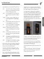
Bei der T2-Variante zeigt ein roter und gelber Pfeil auf der linken oder
rechten Seite an, dass der Pilot entweder nach links oder nach rechts
abbiegen muss, um die Mittellinie abzufangen. Der gelbe Pfeil zeigt
an, wie groß die aktuelle Abweichung ist. Ein Pfeil auf der linken
Seite, der nach RECHTS zeigt, bedeutet zum Beispiel, dass der Pilot
nach rechts korrigieren muss.
Die T1-Variante verhält sich ähnlich wie die T2-Variante, mit dem
Unterschied, dass das Flugzeug (als Pfeil dargestellt) in Relation zur
Mittellinie auf dem Anzeigefeld angezeigt wird. So lässt sich besser
erkennen, wo sich das Flugzeug in Bezug auf den Haltepunkt
befindet. Das folgende Beispiel zeigt ein Flugzeug in der gleichen
Situation mit der Notwendigkeit, nach rechts zu korrigieren, um die
Mittellinie zu kreuzen. Beachten Sie, dass die Position des Flug-
zeugsymbols links/rechts auf dem Bildschirm anzeigt, wie groß die
Abweichung derzeit ist.

Aerosoft Mega Airport Brussels
Aerosoft GmbH 2022
14 15
Deutsch
Die Abbildung zeigt den Azimut und die Schließgeschwindigkeit der Systeme T2
und T1.
Wenn ein Flugplan über das UI-Menü der VDGS-Module aktiviert
wurde, können Sie auswählen, an welchem Standplatz Sie bei Ihrer
Ankunft in Brüssel parken möchten. Dadurch wird das VDGS-System
automatisch für diesen Standplatz aktiviert.
Wenn Sie einen Flug in Brüssel starten, können Sie über dasselbe
Flugplanmenü Ihr Ziel und die voraussichtliche Abflugzeit eingeben,
die dann auf dem VDGS-Anzeigefeld angezeigt wird. (Der Zielflugha-
fen muss nicht vom VDGS-Modul unterstützt werden.)
Wenn in den VDGS-Moduloptionen die Option „Automatische
Jetway-Verbindung“ aktiviert ist, sollten sich die Jetways automatisch
verbinden, sobald die „OK“-Anzeige erfolgt und die Triebwerke
abgeschaltet werden.
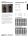
Flughafen Daten
Name: Brüssel-National
ICAO/IATA: EBBR/BRU
Koordinaten: 50° 54‘ 1 „N 04° 29‘ 1 „E
Höhenlage: 175 Fuß / 53 Meter
07L/25R - 3.638 Meter (11.936 Fuß) - Asphalt
07R/25L - 3.211 Meter (10.535 Fuß) - Asphalt
01/19 - 2.987 Meter (9.800 Fuß) - Asphalt
Start- und Landebahnabstände
TORA TODA ASDA LDA
07L 3638m 3638m 3638m 3339m
07R 2893m 2893m 2893m 3089m
25L 3211m 3211m 3211m 3211m
25R 3638m 3638m 3638m 3339m
01 2987m 2987m 2987m 2941m
19 2987m 2987m 2987m 2767m
Intersection Take-off Distances
TWY TORA TWY TORA
01 E1 078 19 A1 2819
01 E3 2028 19 E7 2678
01 E4 1254 19 E6 2163
19 E5 1557
19 E4 1559

Aerosoft Mega Airport Brussels
Aerosoft GmbH 2022
16 17
Deutsch
TWY TORA TWY TORA
07R C6 2405 25L C1 209
07R C4 1802 25L C2 1696
07R PSN1 2624 25L C3 1255
07R PSN2 2344 25L C4 1238
07R PSNH 2893
07R C3 1791
TWY TORA TWY TORA
07L B9 2527 25R A1 3428
07L A6 2645 25R B1 3266
07L B8 2601 25R B3 2760
07L A5 2156 25R B5 1999
07L B7 1842 25R A3 1991
07L B6 1384 25R B6 1988
07L A3 1569 25R B7 1526
07L B5 1517 25R A5 1409
Empfohlene Einstellungen
Die Szenerie an sich erfordert keine besonderen Grafikeinstellungen,
um richtig zu funktionieren.
Für den besten visuellen Effekt wird jedoch empfohlen, die Umge-
bungsunschärfe auf NIEDRIG oder höher einzustellen und die
Online-Funktionen zu aktivieren, insbesondere die “Bing Data World
Graphics” und “Photogrammetry”.
ATC Facilities
Type Name Frequency
ATIS: Brussels ATIS 132.480 MHz
Approach: Brussels Arrival 118.255 MHz
Brussels Arrival 120.105 MHz
Departure: Brussels Departure 126.630 MHz
Tower: Brussel Tower 118.605 MHz
Brussel Tower 120.780 MHz
Ground: Brussel Ground 121.880 MHz
Brussel Ground 118.055 MHz
Delivery: Brussel Delivery 121.955 MHz
Navigational Aids
Description ID Frequency Course
LLZ/DME 01 (CAT l) IBX 109.90 MHz 014° 014°
LLZ/DME 19 (CAT l) IBM 111.15 MHz 194° 194°
LLZ/DME 25L (CAT lll) BL 110.35 MHz 250°
LLZ/DME 25R (CAT lll) IBR 108.90 MHz 245°
VOR/DME Brussels BUB 114.60 MHz

Aerosoft Mega Airport Brussels
Aerosoft GmbH 2022
18 19
Deutsch
Szenerie-Features
• Enthält eine detaillierte Nachbildung vom Flughafens Brüssel
(BRU, EBBR)
• Hochdetaillierte Modelle mit hochauflösenden Texturen
• Benutzerdefinierte Fluggastbrücken mit passenden Variationen
für jeden Terminal-Pier
• Passagierbewegungen in der Umgebung in und um die
Terminals
• Große Mengen an Boden-Clutter und Serviceausrüstungen an
Flugzeugstandplätzen und Parkplätzen
• Benutzerdefinierter Rampenverkehr, der das Vorfeld zum
Leben erweckt
• Modernes Layout der Rollwege, des Vorfelds und der Stand-
plätze
• Benutzerdefinierte und präzise Rollbahnbeschilderung
• Präzise Taxiway-Beleuchtung, einschließlich kundenspezifischer
Landebahnbeleuchtungen
• Anflug- und Landebahnbefeuerung an die realen Gegenstücke
angepasst
• Benutzerdefiniertes Luftbild, das die Flughafengrenzen und die
Umgebung abdeckt
• Genaue Gelände- und Landebahnprofile
• Benutzerdefinierte Windsäcke und andere umgebungsabhäng-
ige Animationen
• Realistische dynamische Beleuchtung für die Nacht
• Funktionierendes “Vorfeld-Warnsystem”
• Terminal-Interieur für Flugsteig A, B und Verbindungsgebäude
• Standplätze unterstützen KI-Verkehr, der über Airline-Park-
codes verfügt
• Näherungsauslöser für Hangartore (TUI & Lufthansa) und
Vorfeldtore (N4 und Sabena aerospace)
• Unterstützt das Aerosoft VDGS Modul mit hochpräzisen T1
und T2 Safedock Systemen
Orthographische Bilder
Orthofotomozaïek, grootschalig, winteropnamen, kleur, 2013-2015,
Vlaanderen
Luftbild Flandern, DHMV II - Farbe
Datensatzkennzeichen d8f6a96e-3234-412f-b872-4a003a8348fb
Orthophotomosaik, mittelgroß, Winterbilder, Farbe, 2014, Flandern
Luftbild Flandern, Winter 2014 - Farbe
Datensatzkennzeichen 26ceeb53-2fda-4266-a542-82866ab74266
Orthofotomosaik, mittelgroß, Winteraufnahmen, Farbe, 2020,
Flandern
Luftbild Flandern, Winter 2020 - Farbe
Datensatzkennzeichnung beaec965-363e-41e6-8943-0ef60b353975
In Umsetzung des flämischen Dekrets über die Wiederverwendung von
Regierungsinformationen wird die Wiederverwendung durch die
Musterlizenz für freie Wiederverwendung geregelt. Das bedeutet, dass
jede kommerzielle oder nicht-kommerzielle Wiederverwendung für
einen unbegrenzten Zeitraum kostenlos erlaubt ist. Die einzige
Bedingung für die Nutzung ist die Verpflichtung, die Quelle anzugeben.

Aerosoft Mega Airport Brussels
Aerosoft GmbH 2022
20 21
English
Starting Off
System Requirements
In order for the scenery “Aerosoft Mega Airport Brussels” to run as
smoothly as possible, you need the following:
• Microsoft Flight Simulator
• OS: Windows 10 (Nov 2019 Update - 1909)
• DirectX: DirectX 11
• CPU: Intel® Core™ i7-4790 or better
• GPU: NVIDIA GeForce GTX 970, GDDR5 or better
• VRAM: 2 GB
• RAM: 16 GB
• HDD: 3,5 GB
Installing and Activation
Installing the DLC “Aerosoft Mega Airport Brussels” is straight
forward. Simply run the installer and it will find your MSFS location. It
will ask for the product Key (Authorization Code, or Registration Key)
to activate product. Once installation process completes, the product
should be fully functional within your MSFS sim platform. No need to
manually activate the product in-sim.
FINDING THE AIRPORT IN MICROSOFT FLIGHT
SIMULATOR
You will find the the airport by selecting selecting “Brussels” on the
airport selection map. Alternatively you can select it by typing in the
following ICAO identifier using the departure airport field on the
simulator’s map screen: EBBR
Support
Support for this product is offered by Aerosoft. We prefer to have a
support forum for the simple reason that it is fast and efficient
because customers help customers when we are not in the office:
http://forum.aerosoft.com/
And we advise the Scenery section in the Microsoft Flight Simulator
subforum for any questions on this product. This should be your first
stop for any support. If you prefer support by email please do accept
that this could take a bit longer as it might be sent from person to
person if necessary, and that email support during the weekends is
always slow:
https://helpdesk.aerosoft.com/portal/home
We feel strongly about support. Buying one of our products gives you
the right to waste our time with questions you feel might be silly.
They are not.
Copyrights
This software, the manual, documentation, video images, and all the
related materials are protected by copyright laws. The software is
licensed, not sold. You may install and run one copy of the software
on one computer for your personal, non-commercial use. The
software, the manual and all related materials must not be copied,
photocopied, translated, reverse engineered, decompiled or reduced
to any electronic medium or machine legible form, neither completely
nor in part, without the previous written permission of the developers
of this software and Aerosoft GmbH.

Aerosoft Mega Airport Brussels
Aerosoft GmbH 2022
22 23
English
The Airport
Approach Brussels, the heart of Europe! Not just the capital of
Belgium, but by many seen as the de facto capital of Europe, being
the center stage for European and global politics post WW2 and the
home to numerous companies and NGOs.
A bustling city also needs an airport capable of handling anything
from the average tourist, suitcase toting CEO, overworked diplomat
or even a head of state or two.
Brussels Airport, or Brussels-National as it’s also known is located 12
km north-east of Brussels in the municipality of Zaventem. Serving
close to 25 million passengers in 2019 it clocked in as the 24th
busiest airport in Europe.
Featuring three runways the longest being just above 3,600m laid out
as two parallel runways (07L/25R & 07R/25L) and one crosswind
runway (01/19).
Just north of Brussels airport you’ll find Melsbroek Air Base, home to
the Belgian Air Forces transport wing. Even though it’s defined as it’s
own airfield it shares the same runways as Brussels airport.
History
The areas aviation history began during the first world war with the
construction of a hangar used to house German airships. After the
war the hangar and other facilities which were located in what was
then known as the municipalities of Haren and Evere in the north-
eastern part of Brussels due west of where the current airport is
located.
The great advances seen in aviation during the interwar period the
amount of civilian air traffic kept increasing. In the 1920s a new
Terminal was approved for construction and was opened in 1929
along with a concrete apron for passenger comfort.
The airport at the time wasn’t much more than a large grass field
with the aircraft simply taking off in the direction with the most
favorable winds.
At first mainly being served by Sabena (Belgiums national airline at
the time) the 1930’s saw operations from multiple international
airlines such as Lufthansa, KLM and Air France.
With the large increase of air traffic and no end in sight many voiced
the need to further expand and modernization of the airfield to better
suit the needs of the future.
This would not come to pass as the fragile peace in Europe would be
shattered with the outbreak of the second world war in 1939.
The airport at it’s current location has it’s origins in 1940 after the
German occupation of Belgium when construction of three runways
in a triangular shape began, intended as a backup airfield for the
luftwaffe. The airfield, then known as “Fliegerhorst Melsbroek”
would lay the foundation of the airport as seen today.
As for why this specific area was chosen a local legend has emerged,
when the German occupiers asked the locals which area would be
suitable for an airfield they happily pointed out this plot of land, well
knowing that this area was notorious for being covered in fog.
After the end of the second world war civilian air traffic gradually
moved from Haren to Melsbroek and in 1948 the civilian aerodrome
at Melsbroek was opened.
As with the rapid expanse of civilian traffic during the jet age airport
facilities and runways were constantly adapted to meet the ever-
changing requirements.
In 1973 what is known as the “Satellite” was finished and taken into
use. This building, although now converted to office space still stands
to this day.
The modern Terminal layout of Brussels now consists of two piers,
known as A and B. These are connected through a building (simply
named the “Connector”) replacing an underground tunnel previously
used to transit from the two piers. Pier A serves as domestic and EU/
Schengen flights while Pier B is used for International flights.

Aerosoft Mega Airport Brussels
Aerosoft GmbH 2022
24 25
English
A Dynamic Airport
The scenery utilizes a large amount of scripting to bring the airport to
life. These scripts ranges from simple go here then go here commands
given to passengers moving around the terminal or vehicles driving
around the apron service roads to more complex scripts.
Apron Warning System
If you take a closer look at the airport you’ll see that scattered around
is a three light system known as the apron warning system, these are
usually mounted high up on floodlights or walls to be easily seen by
apron workers. A orange light is illuminated during high winds and
gusts, a red light when there’s possibility for thunderstorms and
during snow/icing conditions a blue light is illuminated.
Image shows the Apron Warning system during different conditions
Dynamic Hangar Doors
Some of the Hangar Doors (TUI and Lufthansa Hangars) and ramp
gates (on TWY N4 and next to the Sabena Aerospace Hangar) will
automatically open and close as you approach or leave the area.
The TUI hangar scripts also has some randomness built into it, so at
certain times the hangar “wake up” and trigger animations at
random, helping to bring some more life and busyness to the airport.
If you approach the TUI hangar while one of these random anima-
tions are playing they’ll need to finish before the Hangar doors open
due to your aircraft proximity.
AI Traffic
The scenery supports AI traffic with ICAO defined parking codes. In
general these codes tells the AI traffic where it’s allowed to park. In
general this is used to prevent Cargo traffic parking around the
terminals and a more realistic layout of where the different airlines
park. This has some limitations, mainly if there’s an overflow where
the AI traffic can’t find a stand with an appropriate ICAO code it’s
going to park at a random stand. The ICAO codes are also not taken
into account when placed as static aircraft through the “Ground
Aircraft Density” Setting. Found here: Option – General Options –
Traffic
Visual Guidance Docking System
(VDGS)
The scenery supports the Aerosoft VDGS module with highly realistic
Safedock T1 and T2 systems.
Stands 140-171, 204-230, 232, 234, 233R & 235 are equipped with
the T2-18 variant.
Stands 680-699 & 957-999 are equipped with the T2-18 variant.
Stands 231 & 233L are equipped with the T1 variant.
These systems are highly accurate to the real world counterparts and
the following section gives a quick introduction to the different states,
information and warnings.
This is a short introduction into the VDGS and it’s functionality, for

Aerosoft Mega Airport Brussels
Aerosoft GmbH 2022
26 27
English
more information please see the dedicated VDGS modules Manual.
WAIT Indicates that the system is initializing, you should not
approach the stand. Hold the position until the correct
AC type and the rolling arrows is shown.
SLOW If the aircraft approaches the stand at speed consid-
ered unsafe the pilot is warned of the need to slow
down.
STOP/OK A continuous cycle between STOP/OK indicates the
aircraft has stopped short of it’s assigned stopping
point.
STOP A solid STOP message indicates the aircraft has reached
it’s assigned stopping point and needs to stop.
OK After the aircraft has stopped at it’s assigned stopping
point the STOP indication changes to a solid OK.
TOO FAR A TOO FAR indication indicates that the aircraft has
passed the assigned stopping point and must immedi-
ately stop.
ID FAIL An ID FAIL message indicates that the system is unable
to identify the user aircraft the fallback stopping point
is then assigned.
EOBT This information is the Estimated Of Block Time, this is
entered in the flight plan section in the VDGS module
UI menu. (Given as UTC)
AOBT This information is the Actual Of Block time, displayed
as the aircraft is leaving the stand. (Given as UTC)
When the aircraft is further away than 20 M from it’s stopping point
the AC TYPE / FLT NR cycles. Along with the display of the rolling
arrows on the lower section of the display panel.
As the aircraft is within 20 M of the stopping point the systems
azimuth and closing rate guidance is activated. These varies a little
between the T1 and T2 systems.
For the T2 variant a Red and Yellow arrow displayed on the Left or
Right side indicates that the pilot needs to turn either left or right to
intercept the center line. The yellow arrow indicates how large the
deviation currently is. As an example a arrow on the left side pointing
RIGHT indicates the pilot needs to correct towards the right.
The T1 variant behaves in a similar way as the T2 except for the
aircraft (shown as an arrow) being displayed in relation to the center
line seen on the display panel. Giving a more visual representation of
where the aircraft is located in relation to the stopping point. The
example below shows an aircraft in the same situation with the need
to correct to the right to intercept the center line. Note that the
aircraft symbols left/right position on the screen indicates how large
the deviation currently is.
Image shows the azimuth and closing rate of the T2 and T1 systems.
If a flightplan is activated using the VDGS modules UI menu you can
select which stand you plan to park at when arriving at Brussels. This
automatically activate the VDGS system for that stand.
When starting a flight at Brussels you can use the same flight plan
menu to enter your destination and estimated off-block time, which
then is displayed on the VDGS display panel.
(The destination airport does not need to be supported by the VDGS
module.)
If “Automatic Jetway connection” is enabled in the VDGS module
options the jetways should automatically connect when the “OK”
indication is given and engines are shut off.

Aerosoft Mega Airport Brussels
Aerosoft GmbH 2022
28 29
English
Airport Data
Name: Brussels-National
ICAO/IATA: EBBR/BRU
Coordinates: 50° 54’ 1”N 04° 29’ 1”E
Elevation: 175 feet / 53 meters
07L/25R - 3,638 meters (11,936 feet) - Asphalt
07R/25L - 3,211 meters (10,535 feet) - Asphalt
01/19 - 2,987 meters (9,800 feet) - Asphalt
Declared Runway Distances
TORA TODA ASDA LDA
07L 3638m 3638m 3638m 3339m
07R 2893m 2893m 2893m 3089m
25L 3211m 3211m 3211m 3211m
25R 3638m 3638m 3638m 3339m
01 2987m 2987m 2987m 2941m
19 2987m 2987m 2987m 2767m
Intersection Take-off Distances
TWY TORA TWY TORA
01 E1 078 19 A1 2819
01 E3 2028 19 E7 2678
01 E4 1254 19 E6 2163
19 E5 1557
19 E4 1559
TWY TORA TWY TORA
07R C6 2405 25L C1 209
07R C4 1802 25L C2 1696
07R PSN1 2624 25L C3 1255
07R PSN2 2344 25L C4 1238
07R PSNH 2893
07R C3 1791
TWY TORA TWY TORA
07L B9 2527 25R A1 3428
07L A6 2645 25R B1 3266
07L B8 2601 25R B3 2760
07L A5 2156 25R B5 1999
07L B7 1842 25R A3 1991
07L B6 1384 25R B6 1988
07L A3 1569 25R B7 1526
07L B5 1517 25R A5 1409
Recommended Settings
The scenery in itself doesn’t require any specific graphics settings to
function properly.
However for the best visual effect it’s recommended to set the
Ambient Occlusions to LOW or higher and enable the Online func-
tionality, mainly the “Bing Data World Graphics” and “Photogramme-
try”.

Aerosoft Mega Airport Brussels
Aerosoft GmbH 2022
30 31
English
ATC Facilities
Type Name Frequency
ATIS: Brussels ATIS 132.480 MHz
Approach: Brussels Arrival 118.255 MHz
Brussels Arrival 120.105 MHz
Departure: Brussels Departure 126.630 MHz
Tower: Brussel Tower 118.605 MHz
Brussel Tower 120.780 MHz
Ground: Brussel Ground 121.880 MHz
Brussel Ground 118.055 MHz
Delivery: Brussel Delivery 121.955 MHz
Navigational Aids
Description ID Frequency Course
LLZ/DME 01 (CAT l) IBX 109.90 MHz 014° 014°
LLZ/DME 19 (CAT l) IBM 111.15 MHz 194° 194°
LLZ/DME 25L (CAT lll) BL 110.35 MHz 250°
LLZ/DME 25R (CAT lll) IBR 108.90 MHz 245°
VOR/DME Brussels BUB 114.60 MHz
Scenery Features
• Includes a highly accurate recreation of Brussels Airport (BRU,
EBBR)
• Highly detailed models with high resolution textures.
• Custom jetways with correct variations for each terminal pier.
• Ambient passenger movements inside and around the
terminals.
• Large amounts of ground clutter and service equipment at
aircraft stands and parkings.
• Custom ambient ramp traffic bringing the apron to life.
• Up to date taxiway, apron and stands layout.
• Custom and accurate taxiway signage.
• Accurate taxiway lighting including custom runway guard lights.
• Approach and runway lights adapted to match real world
counterparts.
• Custom aerial image covering the airport boundary and
surrounding area.
• Accurate terrain and runway profiles.
• Custom windsocks and other environment dependent
animations.
• Realistic night time dynamic lighting.
• Functioning “Apron Warning System”.
• Terminal interior for Pier A, B and connector building.
• Stands support AI traffic that has airline parking codes.
• Proximity triggers for hangar doors (TUI & Lufthansa) and
apron gates (N4 and Sabena aerospace).
• Supports the Aerosoft VDGS module with highly accurate T1
and T2 safedock systems.

Aerosoft Mega Airport Brussels
Aerosoft GmbH 2022
32 MF
Orthographic Images
Orthofotomozaïek, grootschalig, winteropnamen, kleur, 2013-2015,
Vlaanderen
Aerial view Flanders, DHMV II - color
Dataset identifier d8f6a96e-3234-412f-b872-4a003a8348fb
Orthophotomosaic, medium-scale, winter images, color, 2014,
Flanders
Aerial view Flanders, winter 2014 - color
Dataset identifier 26ceeb53-2fda-4266-a542-82866ab74266
Orthophotomosaic, medium-scale, winter shots, color, 2020, Flanders
Aerial view Flanders, winter 2020 - color
Dataset identifier beaec965-363e-41e6-8943-0ef60b353975
In implementation of the Flemish Decree for the reuse of government
information, the reuse is regulated by means of the Model License for
free reuse. This means that any commercial or non-commercial reuse
is allowed for an indefinite period, at no cost. The sole condition of
use is an obligation to acknowledge the source.

Aerosoft Mega Airport Brussels
Aerosoft GmbH 2022
33 MF
WWW.AEROSOFT.COM
WIN OTTER
AEROSOFT
T
AIRCRAFT
D LC
DISCOVER THE NEW
AEROSOFT AIRCRAFTS
RJ BUNDLE
C
AEROSOFT
CRJ 550/700/900/1000
AIRCRAFT
-
 1
1
-
 2
2
-
 3
3
-
 4
4
-
 5
5
-
 6
6
-
 7
7
-
 8
8
-
 9
9
-
 10
10
-
 11
11
-
 12
12
-
 13
13
-
 14
14
-
 15
15
-
 16
16
-
 17
17
-
 18
18


Sim-Wings Mega Airport Brussels Benutzerhandbuch
- Typ
- Benutzerhandbuch
in anderen Sprachen
Verwandte Artikel
-
 Sim-Wings Berlin Brandenburg Airport Instructions Manual
-
 Sim-Wings Mega Airport Frankfurt Flight Simulator 2004 Flight Simulator X Benutzerhandbuch
-
 Sim-Wings Mega Airport Frankfurt v2.0 Flight Simulator X Prepar3D Benutzerhandbuch
-
 Sim-Wings Mega Airport Berlin Brandenburg Professional Benutzerhandbuch
-
 Sim-Wings Mega Airport Paris Orly Benutzerhandbuch
-
 Sim-Wings Mega Airport Prag Bedienungsanleitung
-
 Sim-Wings Mega Airport Zurich v2.0 Bedienungsanleitung
-
 Sim-Wings Köln Bonn Professional Benutzerhandbuch
-
 Sim-Wings Trondheim-Vaernes X v2.0 Benutzerhandbuch
-
 Sim-Wings German Airports 1 Stuttgart Flight Simulator 2004 Flight Simulator X Prepar3D Benutzerhandbuch


